Exploring India’s Rivers and Wildlife Regions
India’s rivers don’t just cut through landscapes; they shape how people move, where towns form, and how wildlife survives alongside everything else. Following them often leads to places that feel more layered than a typical itinerary stop. One stretch might pass tea estates and river islands; another, mangrove forests where land and water keep shifting.
It’s not always easy to get around, but that’s part of the appeal. Routes depend on ferries, narrow roads, or boats that run on local schedules. The five regions below show how India’s rivers influence daily life, wildlife, and travel in ways that are easy to overlook at first.
Boutique River Expeditions on the Brahmaputra
In Assam, the Brahmaputra isn’t a background feature. It dictates movement across the region. From Guwahati, most river journeys begin near the Pandu port area, where boats head upstream past sandbars and small river islands known as chars. These islands shift with the seasons, so routes rarely stay the same year to year. Stops often include Majuli, one of the world’s largest river islands, where narrow roads connect satras (Vaishnavite monasteries) and villages built slightly above flood level.
The appeal of these journeys lies in how they connect otherwise hard-to-reach areas. For instance, some of the most amazing India cruises that focus on the Brahmaputra follow routes that would be difficult to piece together overland, linking places like Majuli’s monastery clusters with smaller riverbank settlements and tea-growing districts further upstream, all while using the river itself as the main route between them.
On land, moving between places like Sibsagar and Jorhat usually means long drives, but by water, the transitions feel more direct. It’s less about racing through key attractions and more about understanding how people live alongside a river that constantly changes its course.
Tiger Tracking in the Mangroves of the Sundarbans
The Sundarbans lie at the delta where the Ganges, Brahmaputra, and Meghna rivers meet before emptying into the Bay of Bengal. From Kolkata, the journey typically starts with a drive south to Godkhali, followed by a boat transfer into the mangrove network. Roads give way to waterways, and villages appear as clusters along embankments.
Tiger tracking here doesn’t involve walking safaris in the usual sense. Boats move slowly through channels, like the Matla River and narrower creeks branching off toward watchtowers at places such as Sajnekhali and Sudhanyakhali. The forest is dense, and sightings aren’t guaranteed, but guides watch for subtle signs along the banks, including paw prints in the mud or movement in the mangrove roots. Crocodiles and spotted deer are more commonly seen, especially in the early hours.
Movement between zones is regulated, so most routes follow a set pattern through designated channels. Even so, each day feels slightly different depending on tides and visibility. The Sundarbans aren’t a place where things line up neatly. It requires patience, and sometimes long stretches of water pass without much happening. Suddenly, something shifts, and the whole environment feels alert again.
Houseboat Heritage and Backwater Serenity in Kerala
Kerala’s backwaters run parallel to the Arabian Sea, forming a network of canals, lakes, and narrow channels that link towns like Alappuzha, Kumarakom, and Kottayam. Houseboats usually depart from the Finishing Point area in Alappuzha, where boats line up along the canal before heading out into Vembanad Lake. From there, routes branch into smaller waterways that pass rice paddies, coconut groves, and villages built close to the water’s edge.
The movement is slow, but the details keep it interesting. Ferries cross at regular intervals, children walk along narrow paths between canals, and small shops sit just a few steps from the water. In Kumarakom, the area around the bird sanctuary draws boats into quieter stretches where herons and kingfishers are easier to spot. Getting between Alappuzha and Kumarakom by road takes under an hour. By boat, the route stretches into a full day.
What stands out is how daily life runs through the waterways. This isn’t a separate tourist zone. People commute, trade, and organise their routines along the same canals that visitors travel through. It’s easy to see how the system has functioned this way for generations without needing major change.
Pristine Riparian Habitats of Kaziranga National Park
Kaziranga sits along the southern banks of the Brahmaputra, and the river plays a major role in shaping the park’s ecology. Seasonal flooding replenishes the grasslands, which in turn support large populations of wildlife. The park is divided into ranges like Kohora, Bagori, and Agaratoli, each with its own entry gate and safari routes. Most visitors base themselves near Kohora, where the main road connects lodges and jeep safari starting points.
Early morning safaris often follow tracks that run alongside water bodies formed by previous floods. These areas attract rhinos, elephants, and swamp deer, especially when the grass is shorter after the monsoon season. The Bagori range, accessible via the western entrance, tends to offer good visibility, while Agaratoli in the east is known for birdlife along the wetlands.
Getting between ranges usually involves driving along National Highway 37, which runs parallel to the Kaziranga park. It’s not a large distance on the map, but traffic and road conditions can slow things down. The link between the river and the park is clear once inside. Without the annual flooding, the grasslands wouldn’t regenerate in the same way, and the wildlife patterns would look very different.
Sacred Confluences and Spiritual Rituals in Varanasi
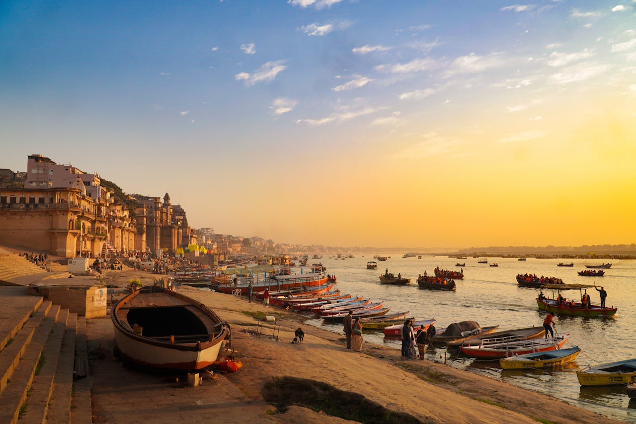
Varanasi sits along the Ganges, and most of the city’s activity concentrates near the riverfront. The ghats form a continuous stretch of steps leading down to the water, each with its own purpose. Dashashwamedh Ghat is where the evening aarti takes place, drawing crowds that gather along the steps and on boats anchored just offshore. A short walk north leads to Manikarnika Ghat, where cremation rituals continue throughout the day and night.
The older parts of the city unfold behind these ghats. Narrow lanes connect places like Vishwanath Gali to the Kashi Vishwanath Temple, with markets selling flowers, textiles, and ritual items. Moving through this area means navigating a mix of pedestrians, scooters, and the occasional cow blocking the way. It’s dense, but the layout becomes easier to understand after a few passes.
Boats leave from Assi Ghat in the south and move north along the river, offering a view of the ghats in sequence. Early morning trips tend to be quieter, with fewer crowds along the steps. By evening, the atmosphere shifts again as people gather for rituals. The river isn’t just a landmark here; it’s central to how the city functions every day.
Which river path will you follow?
Each of these regions shows a different side of how rivers shape travel in India. Some routes rely on boats because roads aren’t practical, while others use waterways as part of everyday life. Wildlife areas like Kaziranga and the Sundarbans depend on river systems to sustain their ecosystems, while places like Varanasi revolve around long-standing cultural practices tied to the water. Choosing between them comes down to what kind of experience feels more relevant, whether that’s wildlife tracking, cultural immersion, or simply understanding how movement works in places built around rivers.